CELESTIAL MAPS
is the fourth variant which produces accurate
maps of the sky in five types of projections,
by using two professional catalogues of the stars.
If you wish a general
map of the northern or southern sky, then
pick the first type. This branch feigns the
movement of the planets and the Sun on the
sky, if you introduce a start time and the positive or negative step. Also,
it can trace the fundamental lines of the sky.
If you want a very
precise chart of a random area, you must pick
the second type. This branch optionally makes use of a simple
data base (containing stars up to magnitude
6th, and producing charts without limit of the field), or access
a large data base
(containing stars up to magnitude 12th
and producing maps up to 20 degrees field). In the second case, you could
select the name of the stars in four
catalogue denominations (PPM, SAO, HD, DM).
This second branch of the program is equipped with three types of
projection which can be selected optionally. For a more precise chart of
a random area, you can make an option which reduces
the stars to a desired epoch (corrections
for precession, aberration, nutation, proper motions). The user can search
an object in the sky by selecting from three
files ("sse.dat","nse.dat" or "cse.dat") a star (by name, PPM or SAO number),
a non-stellar object (from the Messier catalogue), or a constellation,
respectively. You can add other objects
to these files. Also, you can modify the size of the field and the limiting
magnitude and select a normal or overturned image. Three
possibilities for displaying; the stars
in the field are proposed by the program (one of these by setting
an optional range of magnitudes, in maximum nine levels). Also,
12 colors of the stars
are used to give information about the spectral type of the stars. This
second branch produces files ("placa1.dat",
"placa2.dat" etc) containing information's about the stars appearing in
the field (which could be used in the reduction of the photographical
plates.
If you want the
general image of the sky at any time and place,
this can be selected from the third type of projection. In this case,
CELESTIAL MAPS will draw for you the planets,
according to the magnitude which is calculated depending on the planets'
phases. Also, both Sun and Moon
(with phases)
are drawn. You can select the names of the planets if you wish.
This program can draw both maps with
or without the constellation lines
and their names.
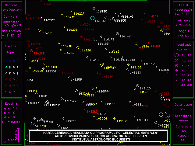
CELESTIAL MAPS
uses two professional 2000-epoch catalogues
of stars : "Catalogue of Positions
and Proper Motions" (PPM) and "Smithsonian Astrophysical Observatory
Catalogue" (SAO), selected from CD-ROM (courtesy
by NASA). This selection increases the speed of execution and
decreases the disk space. The choice of one of these is made in the second
branch of the program by selecting the option "large data base".
The files containing the stars ppms9.dat", ..., "ppmn9.dat", respectively
"saos9.dat", ..., "saon9.dat" - type files) represent stripes of 10 degrees
of declination. Thus, the user can install partial database,
in conformity with the disk space and the field of interest.
The simple data base ("saostele.dat") is also a type file.
Also, there is another file ("stars.dat" - a text file) which contains
additional stars, that can be modified by the user. These files contain
the coordinates, magnitude, the spectral type (which produces a color image
of the sky and a size of the stars depending on their magnitudes),
the proper motions and five denominations. There is another file
containing the constellations ("const.dat"). The
initialization of the variables used is made
in the file "maps.ini". To use other options, you could change the
variables in the program and save these at the end.
This program is endowed with printer
facilities of the sky maps. In order to print,
it must pick up the type of the printer (pin or inkjet) and after
obtaining a chart on the display, the connection of the printer
must be verified and <Ctrl>+<Print Screen> must be pressed. It's
also possible to print the maps by using other utilities.
The program is endowed with a color
menu which is very user friendly.
CELESTIAL MAPS
is written in TURBO PASCAL 7.0
and requires an IBM PC, XT, AT or compatible, 1 unit floppy disk
min 1MB (simple data base) or hard disk space min 16MB (SAO large data
base) and/or; 20MB (PPM large data base), (16 colors) graphics display
CGA or EGA/VGA, printer.
Dr._Mirel_BIRLAN at Astronomical Institute in Bucharest is the co-author
of the former versions 1.0, 3.1 and 4.5 of this package.
For more information or suggestion related to the program or requires
regarding the purchase, please contact the author.